
Make a donation
Gear up for your next adventure:
As an Amazon Associate, this site earns from qualifying purchases at no extra cost to you.
Laufenselden topographic map
Click on the map to display elevation.
Make a donation
Gear up for your next adventure:
As an Amazon Associate, this site earns from qualifying purchases at no extra cost to you.
About this map
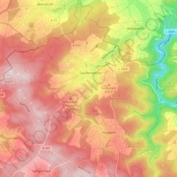
Name: Laufenselden topographic map, elevation, terrain.
Location: Laufenselden, Heidenrod, Rheingau-Taunus-Kreis, Hesse, Germany (50.17443 7.94648 50.23876 8.03816)
Average elevation: 415 m
Minimum elevation: 197 m
Maximum elevation: 545 m
Make a donation
Gear up for your next adventure:
As an Amazon Associate, this site earns from qualifying purchases at no extra cost to you.
Other topographic maps
Click on a map to view its topography, its elevation and its terrain.
Wehener Wand und Rentmauer Wiesbaden
Germany > Hesse > Rheingau-Taunus-Kreis > Wiesbaden
Average elevation: 377 m
Make a donation
Gear up for your next adventure:
As an Amazon Associate, this site earns from qualifying purchases at no extra cost to you.
Teufelskadrich bei Lorch
Germany > Hesse > Rheingau-Taunus-Kreis > Rüdesheim am Rhein > Assmannshausen
Average elevation: 253 m