Geolocate

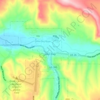
John Day topographic map

Click on the map to display elevation.

John Day

John Day is at an elevation of 3,087 feet (941 m). According to the United States Census Bureau, the city has a total area of 1.87 square miles (4.84 km2), all land.

Wikipedia (CC-BY-SA 3.0)

About this map

Name: John Day topographic map, elevation, terrain.

Location: John Day, Grant County, Oregon, 97845, United States (44.40318 -118.98629 44.43233 -118.91518)

Average elevation: 1,047 m

Minimum elevation: 918 m

Maximum elevation: 1,254 m

Other topographic maps

Click on a map to view its topography, its elevation and its terrain.

Kimberly

United States > Oregon > Grant County

Average elevation: 711 m

Dale

United States > Oregon > Grant County

Average elevation: 1,035 m

Gear up for your next adventure:

🪢Paracord - Multi-purpose cord for camping and survival
📱Rugged Phone Cases - Heavy-duty protection for smartphones used as secondary GPS tools
🥾Hiking Boot Waterproofing Wax - Maintain the lifespan of your leather trekking boots
🧰Survival Kits - Emergency tools for remote environments
🍱Food Containers - Reusable containers for outdoor meals

As an Amazon Associate, this site earns from qualifying purchases at no extra cost to you.