Geolocate

Clanton topographic map

Click on the map to display elevation.

About this map

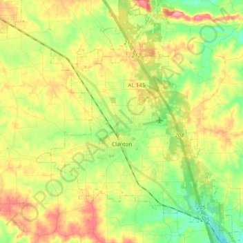
Name: Clanton topographic map, elevation, terrain.

Location: Clanton, Chilton County, Alabama, United States (32.78754 -86.68439 32.91398 -86.55783)

Average elevation: 188 m

Minimum elevation: 137 m

Maximum elevation: 250 m

Other topographic maps

Click on a map to view its topography, its elevation and its terrain.

Gear up for your next adventure:

🍳Camping Stoves - Compact stoves for outdoor cooking
🧤Hiking Gloves - Warm and durable gloves for cold-weather walks
📍Handheld GPS Navigators - Reliable satellite navigation for hiking and off-road exploration
👖Hiking Trousers - Durable trousers designed for rough terrain
🔦Outdoor Torches - Reliable torches for night navigation

As an Amazon Associate, this site earns from qualifying purchases at no extra cost to you.