
Thank you for supporting this site ❤️
Make a donation
Make a donation
Gear up for your next adventure:
As an Amazon Associate, this site earns from qualifying purchases at no extra cost to you.
Ayotlán topographic map
Click on the map to display elevation.
Thank you for supporting this site ❤️
Make a donation
Make a donation
Gear up for your next adventure:
As an Amazon Associate, this site earns from qualifying purchases at no extra cost to you.
About this map
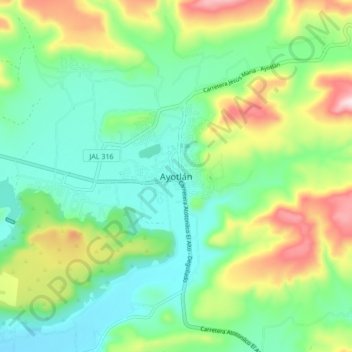
Name: Ayotlán topographic map, elevation, terrain.
Location: Ayotlán, Región Ciénega, Jalisco, 47930, Mexico (20.48873 -102.36905 20.56873 -102.28905)
Average elevation: 1,697 m
Minimum elevation: 1,565 m
Maximum elevation: 1,980 m
Thank you for supporting this site ❤️
Make a donation
Make a donation
Gear up for your next adventure:
As an Amazon Associate, this site earns from qualifying purchases at no extra cost to you.