Geolocate

Bosstraat topographic map

Click on the map to display elevation.

About this map

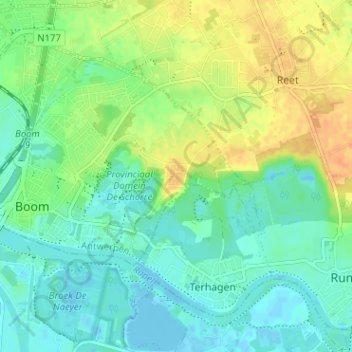
Name: Bosstraat topographic map, elevation, terrain.

Location: Bosstraat, Boom, Antwerp, Flanders, 2840, Belgium (51.07083 4.37287 51.11083 4.41287)

Average elevation: 12 m

Minimum elevation: -3 m

Maximum elevation: 31 m

Gear up for your next adventure:

🧰Survival Kits - Emergency tools for remote environments
📐Altimeters & Barometers - Tools for measuring altitude and air pressure
🧼Camping Hygiene Kits - Compact hygiene essentials for outdoor stays
📷Outdoor Action Cameras - Cameras designed for hiking and adventure
🧊Insulated Flasks - Keeps drinks hot or cold during hikes

As an Amazon Associate, this site earns from qualifying purchases at no extra cost to you.