
Thank you for supporting this site ❤️
Make a donation
Make a donation
Gear up for your next adventure:
As an Amazon Associate, this site earns from qualifying purchases at no extra cost to you.
Mopertingen topographic map
Click on the map to display elevation.
Thank you for supporting this site ❤️
Make a donation
Make a donation
Gear up for your next adventure:
As an Amazon Associate, this site earns from qualifying purchases at no extra cost to you.
About this map
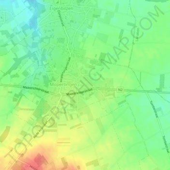
Name: Mopertingen topographic map, elevation, terrain.
Location: Mopertingen, Bilzen, Tongres, Limbourg, Flandre, Belgique (50.85584 5.56287 50.86850 5.59561)
Average elevation: 90 m
Minimum elevation: 64 m
Maximum elevation: 124 m
Thank you for supporting this site ❤️
Make a donation
Make a donation
Gear up for your next adventure:
As an Amazon Associate, this site earns from qualifying purchases at no extra cost to you.