Geolocate

Towson topographic map

Click on the map to display elevation.

About this map

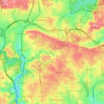
Name: Towson topographic map, elevation, terrain.

Location: Towson, Baltimore County, Maryland, United States (39.37199 -76.66714 39.42101 -76.56303)

Average elevation: 114 m

Minimum elevation: 56 m

Maximum elevation: 168 m

Other topographic maps

Click on a map to view its topography, its elevation and its terrain.

Ruxton

United States > Maryland > Baltimore County > Towson

Average elevation: 105 m

Riderwood

United States > Maryland > Baltimore County > Towson

Average elevation: 106 m

Gear up for your next adventure:

🎒Hiking Child Carriers - Explore the outdoors with the whole family safely
🧗Locking Carabiners - Secure gear to your pack or for light technical use
🕶️Glacier Goggles - Maximum protection for high-altitude snow topography
📻Hand-Crank Emergency Radios - Stay updated on weather warnings in remote areas
🧴Sport Sunscreen Sticks - High-protection sunblock that won't run into your eyes on the trail

As an Amazon Associate, this site earns from qualifying purchases at no extra cost to you.