
Make a donation
Gear up for your next adventure:
As an Amazon Associate, this site earns from qualifying purchases at no extra cost to you.
Miliana topographic map
Click on the map to display elevation.
Make a donation
Gear up for your next adventure:
As an Amazon Associate, this site earns from qualifying purchases at no extra cost to you.
Miliana
Due to its position in mountainous terrain, the elevation of Miliana differs greatly, ranging from 430 metres (1,410 ft) to 870 metres (2,850 ft). It is built on a rocky shelf with steep edges on the southern slopes of Mount Zaccar Rherbi[fr], which covers its entire northern border and reaches 1,550 metres (5,090 ft). There is also a smaller ridge to the south that reaches 700 metres (2,300 ft), separating Miliana from Khemis Miliana. The area around the town is well forested. To the east and south is the Chélif River Valley, and to the west is a large plateau that stretches to the Ouarsenis range.
Make a donation
Gear up for your next adventure:
As an Amazon Associate, this site earns from qualifying purchases at no extra cost to you.
About this map
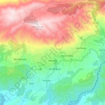
Name: Miliana topographic map, elevation, terrain.
Location: Miliana, Miliana District, Aïn Defla, Algeria (36.27210 2.19244 36.34942 2.27411)
Average elevation: 840 m
Minimum elevation: 317 m
Maximum elevation: 1,564 m
Make a donation
Gear up for your next adventure:
As an Amazon Associate, this site earns from qualifying purchases at no extra cost to you.
Other topographic maps
Click on a map to view its topography, its elevation and its terrain.