
Glattfelden topographic map
Interactive map
Click on the map to display elevation.
About this map
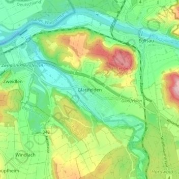
Name: Glattfelden topographic map, elevation, terrain.
Location: Glattfelden, Bezirk Bülach, Zurich, 8192, Switzerland (47.53822 8.45604 47.58121 8.52928)
Average elevation: 413 m
Minimum elevation: 331 m
Maximum elevation: 571 m
Other topographic maps
Click on a map to view its topography, its elevation and its terrain.
Kloten
Switzerland > Zurich > Bezirk Bülach
Kloten has an oceanic climate (Köppen Cfb), with sizeable continental influences due to its relative elevation and distance to any large bodies of water. Precipitation is high year-round and as a result of the cold winter nights, snowfall is frequent in winter. Due to the mild afternoons, this snow seldom…
Average elevation: 478 m