Geolocate

Victoria topographic map

Click on the map to display elevation.

Victoria

Victoria is a city and the county seat of Victoria County, Texas. The population was 65,534 as of the 2020 census. The three counties of the Victoria Metropolitan Statistical Area had a population of 111,163 as of the 2000 census. Its elevation is 95 ft (29 m).

Wikipedia (CC-BY-SA 3.0)

About this map

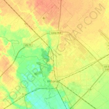
Name: Victoria topographic map, elevation, terrain.

Location: Victoria, Victoria County, Texas, United States (28.76331 -97.05143 28.90575 -96.90027)

Average elevation: 30 m

Minimum elevation: 11 m

Maximum elevation: 45 m

Other topographic maps

Click on a map to view its topography, its elevation and its terrain.

Kemper City

United States > Texas > Victoria County

Average elevation: 30 m

Placedo

United States > Texas > Victoria County

Average elevation: 17 m

Gear up for your next adventure:

👕Merino Base Layers - Natural temperature regulation for cold weather hiking and camping
🌦️Portable Weather Meters - Handheld tools for monitoring weather conditions
🎒Hiking Daypacks - Compact backpacks ideal for short hikes and excursions
🥾Men's Waterproof Hiking Boots - Durable footwear with deep lugs for muddy and rocky UK terrains
📍Handheld GPS Navigators - Reliable satellite navigation for hiking and off-road exploration

As an Amazon Associate, this site earns from qualifying purchases at no extra cost to you.