
Aicha topographic map
Interactive map
Click on the map to display elevation.
About this map
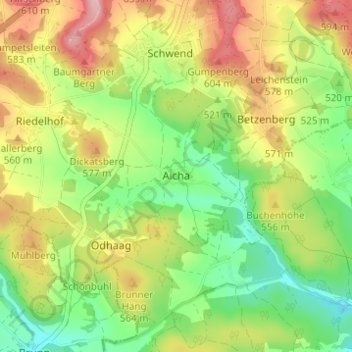
Name: Aicha topographic map, elevation, terrain.
Average elevation: 530 m
Minimum elevation: 456 m
Maximum elevation: 623 m
Other topographic maps
Click on a map to view its topography, its elevation and its terrain.
Poppberg
Deutschland > Bayern > Landkreis Amberg-Sulzbach > Birgland
Poppberg, Birgland, Illschwang (VGem), Landkreis Amberg-Sulzbach, Bayern, 92262, Deutschland
Average elevation: 563 m
Kupfer
Deutschland > Bayern > Landkreis Amberg-Sulzbach > Birgland
Kupfer, Birgland, Illschwang (VGem), Landkreis Amberg-Sulzbach, Bayern, 92262, Deutschland
Average elevation: 542 m
Schwend
Deutschland > Bayern > Landkreis Amberg-Sulzbach > Birgland > Schwend
Schwend, Birgland, Illschwang (VGem), Landkreis Amberg-Sulzbach, Bayern, 92262, Deutschland
Average elevation: 559 m
Dillberg
Deutschland > Bayern > Landkreis Amberg-Sulzbach > Birgland
Dillberg, Birgland, Illschwang (VGem), Landkreis Amberg-Sulzbach, Bayern, 92262, Deutschland
Average elevation: 556 m