Geolocate

Balante topographic map

Click on the map to display elevation.

About this map

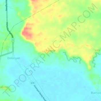
Name: Balante topographic map, elevation, terrain.

Location: Balante, Basey, Samar, Eastern Visayas, Philippines (11.31884 125.02374 11.35884 125.06374)

Average elevation: 19 m

Minimum elevation: 0 m

Maximum elevation: 57 m

Gear up for your next adventure:

📕Outdoor Navigation Books - Learn traditional and modern navigation techniques
🎒Multi-day Trekking Packs - Large capacity backpacks for wild camping and long-distance trails
🧴Tick Removal Tools - Small, essential health tool for UK woodland and moorland
🥤Hydration Bladders - Hands-free hydration systems for backpacks
🐕Dog Hiking Gear - Equipment for hiking safely with dogs

As an Amazon Associate, this site earns from qualifying purchases at no extra cost to you.