
Make a donation
Gear up for your next adventure:
As an Amazon Associate, this site earns from qualifying purchases at no extra cost to you.
Lac-Frontière topographic map
Click on the map to display elevation.
Make a donation
Gear up for your next adventure:
As an Amazon Associate, this site earns from qualifying purchases at no extra cost to you.
About this map
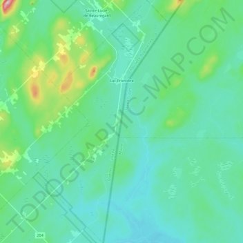
Name: Lac-Frontière topographic map, elevation, terrain.
Average elevation: 384 m
Minimum elevation: 332 m
Maximum elevation: 637 m
Make a donation
Gear up for your next adventure:
As an Amazon Associate, this site earns from qualifying purchases at no extra cost to you.
Other topographic maps
Click on a map to view its topography, its elevation and its terrain.
Morigeau
Canada > Québec > Montmagny (MRC) > Saint-François-de-la-Rivière-du-Sud
Average elevation: 58 m
Archipel de L'Isle-aux-Grues
Canada > Québec > Montmagny (MRC) > Saint-Antoine-de-l'Isle-aux-Grues
Average elevation: 256 m
Make a donation
Gear up for your next adventure:
As an Amazon Associate, this site earns from qualifying purchases at no extra cost to you.
Martineau
Canada > Québec > Montmagny (MRC) > Saint-François-de-la-Rivière-du-Sud
Average elevation: 160 m
Make a donation
Gear up for your next adventure:
As an Amazon Associate, this site earns from qualifying purchases at no extra cost to you.
Archipel de L'Isle-aux-Grues
Canada > Québec > Montmagny (MRC) > Saint-Antoine-de-l'Isle-aux-Grues
Average elevation: 256 m
Les Petites Roches
Canada > Québec > Montmagny (MRC) > Saint-Antoine-de-l'Isle-aux-Grues
Average elevation: 258 m
Make a donation
Gear up for your next adventure:
As an Amazon Associate, this site earns from qualifying purchases at no extra cost to you.