
Sağancı topographic map
Interactive map
Click on the map to display elevation.
About this map
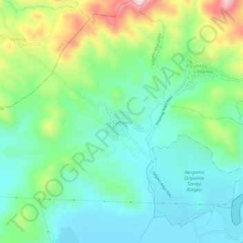
Name: Sağancı topographic map, elevation, terrain.
Location: Sağancı, Bergama, Izmir, Aegean Region, Turkey (39.07103 27.01261 39.11103 27.05261)
Average elevation: 125 m
Minimum elevation: 16 m
Maximum elevation: 387 m
Other topographic maps
Click on a map to view its topography, its elevation and its terrain.
Talatpaşa Mahallesi
Talatpaşa Mahallesi, Bergama, Izmir, Aegean Region, Turkey
Average elevation: 112 m
Gazipaşa Mahallesi
Gazipaşa Mahallesi, Bergama, Izmir, Aegean Region, Turkey
Average elevation: 102 m
İnkılap Mahallesi
İnkılap Mahallesi, Bergama, Izmir, Aegean Region, Turkey
Average elevation: 79 m