Geolocate

Wilrijk topographic map

Interactive map

Click on the map to display elevation.

About this map

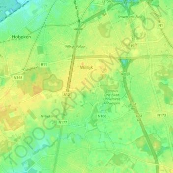
Name: Wilrijk topographic map, elevation, terrain.

Location: Wilrijk, Antwerp, Flanders, 2610, Belgium (51.14329 4.34891 51.18442 4.43515)

Average elevation: 13 m

Minimum elevation: 0 m

Maximum elevation: 22 m

Other topographic maps

Click on a map to view its topography, its elevation and its terrain.

Borgerhout

Belgium > Antwerp > Antwerp > Antwerp

Borgerhout, Antwerp, Flanders, 2140, Belgium

Average elevation: 8 m

Antwerp

Belgium > Antwerp > Antwerp > Antwerp

Antwerp, Flanders, 2030, Belgium, Houtdok

Average elevation: 5 m

Donk

Belgium > Antwerp > Antwerp > Antwerp > Ekeren

Donk, Ekeren, Antwerp, 2180, Belgium

Average elevation: 6 m

Hoboken

Belgium > Antwerp > Antwerp > Antwerp

Hoboken, Antwerp, Flanders, 2660, Belgium

Average elevation: 11 m

Antwerp

Belgium > Antwerp > Antwerp > Antwerp

Antwerp, Flanders, 2000, Belgium

Average elevation: 9 m