
Pogerola topographic map
Interactive map
Click on the map to display elevation.
About this map
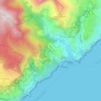
Name: Pogerola topographic map, elevation, terrain.
Location: Pogerola, Amalfi, Salerno, Campania, 84011, Italy (40.61760 14.57182 40.65760 14.61182)
Average elevation: 363 m
Minimum elevation: -3 m
Maximum elevation: 1,118 m
Other topographic maps
Click on a map to view its topography, its elevation and its terrain.