Geolocate

Buwalasi topographic map

Interactive map

Click on the map to display elevation.

About this map

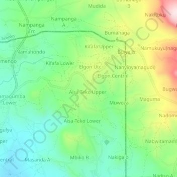
Name: Buwalasi topographic map, elevation, terrain.

Location: Buwalasi, Mbale City, Bugisa sub-region, Eastern Region, Uganda (1.13000 34.19667 1.17000 34.23667)

Average elevation: 1,282 m

Minimum elevation: 1,137 m

Maximum elevation: 1,559 m

Other topographic maps

Click on a map to view its topography, its elevation and its terrain.

Bishop Wasoke

Uganda > Bugisa sub-region > Mbale City

Bishop Wasoke, Mbale City, Bugisa sub-region, Eastern Region, Uganda

Average elevation: 1,129 m

Mukunja

Uganda > Bugisa sub-region > Mbale City

Mukunja, Mbale City, Bugisa sub-region, Eastern Region, Uganda

Average elevation: 1,159 m

Gangama

Uganda > Bugisa sub-region > Mbale City

Gangama, Mbale City, Bugisa sub-region, Eastern Region, Uganda

Average elevation: 1,134 m

Bugembe

Uganda > Bugisa sub-region > Mbale City

Bugembe, Mbale City, Bugisa sub-region, Eastern Region, Uganda

Average elevation: 1,209 m