
Νέα Παλάτια topographic map
Interactive map
Click on the map to display elevation.
About this map
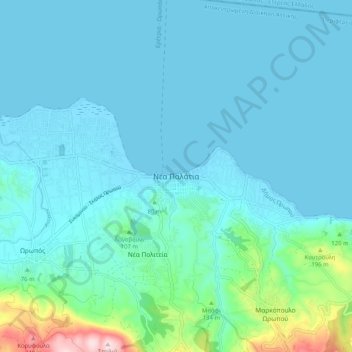
Name: Νέα Παλάτια topographic map, elevation, terrain.
Average elevation: 50 m
Minimum elevation: -2 m
Maximum elevation: 394 m
Other topographic maps
Click on a map to view its topography, its elevation and its terrain.
Κάλαμος
Griekenland > Attica > Περιφερειακή Ενότητα Ανατολικής Αττικής
Κάλαμος, Δήμος Ωρωπού, Περιφερειακή Ενότητα Ανατολικής Αττικής, Attica, 190 17, Griekenland
Average elevation: 242 m
Νέα Μάκρη
Griekenland > Attica > Περιφερειακή Ενότητα Ανατολικής Αττικής > Δημοτική Ενότητα Νέας Μάκρης
Νέα Μάκρη, Δημοτική Ενότητα Νέας Μάκρης, Marathónas, Περιφερειακή Ενότητα Ανατολικής Αττικής, Attica, 190 05, Griekenland
Average elevation: 122 m