
تازه آباد topographic map
Interactive map
Click on the map to display elevation.
About this map
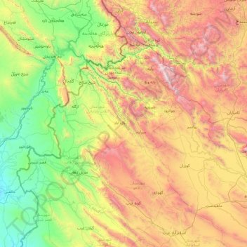
Name: تازه آباد topographic map, elevation, terrain.
Location: تازه آباد, Kermanschah, Iran (34.03127 45.47776 35.43127 46.87776)
Average elevation: 1,214 m
Minimum elevation: 159 m
Maximum elevation: 3,343 m
Other topographic maps
Click on a map to view its topography, its elevation and its terrain.
صحنه
Iran > Kermanschah > شهرستان صحنه > دهستان صحنه
صحنه, دهستان صحنه, بخش مرکزی, شهرستان صحنه, Kermanschah, Iran
Average elevation: 1,509 m
هرسین
Iran > Kermanschah > شهرستان هرسین > دهستان حومه
هرسین, دهستان حومه, بخش مرکزی, شهرستان هرسین, Kermanschah, Iran
Average elevation: 1,671 m
Bisotun
Iran > Kermanschah > Bisotun
Bisotun, چم چمال, بخش بیستون, شهرستان هرسین, Kermanschah, Iran
Average elevation: 1,477 m
کرمانشاه
Iran > Kermanschah > کرمانشاه
Kermānschāh, کرمانشاه, بخش مرکزی, شهرستان کرمانشاه, Kermanschah, ZHIC, Iran
Average elevation: 1,515 m