
Make a donation
Gear up for your next adventure:
As an Amazon Associate, this site earns from qualifying purchases at no extra cost to you.
Saylor topographic map
Click on the map to display elevation.
Make a donation
Gear up for your next adventure:
As an Amazon Associate, this site earns from qualifying purchases at no extra cost to you.
About this map
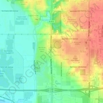
Name: Saylor topographic map, elevation, terrain.
Location: Saylor, Polk County, Iowa, 50313, United States (41.64456 -93.64017 41.68456 -93.60017)
Average elevation: 265 m
Minimum elevation: 239 m
Maximum elevation: 295 m
Make a donation
Gear up for your next adventure:
As an Amazon Associate, this site earns from qualifying purchases at no extra cost to you.
Other topographic maps
Click on a map to view its topography, its elevation and its terrain.
Make a donation
Gear up for your next adventure:
As an Amazon Associate, this site earns from qualifying purchases at no extra cost to you.
Alleman
United States > Iowa > Polk County
Because of its central location and relatively high altitude for central Iowa, two Doppler weather radar stations are located in Alleman: WHO-TV 13's First Alert Mega Doppler, and KCCI-TV 8's Super Doppler 8. A storm in July 2011 resulted in the radome from the Mega Doppler being torn from the structure and…
Average elevation: 303 m
Make a donation
Gear up for your next adventure:
As an Amazon Associate, this site earns from qualifying purchases at no extra cost to you.
Make a donation
Gear up for your next adventure:
As an Amazon Associate, this site earns from qualifying purchases at no extra cost to you.