
Town of North East topographic map
Interactive map
Click on the map to display elevation.
Town of North East
Brace Mountain's 2,311-foot (704 m) summit, near the Connecticut state line in the northeastern corner of town, is the highest point in Dutchess County. The lowest elevation is 530 feet (160 m), along Shekomeko Creek at the Pine Plains town line.
About this map
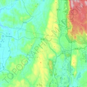
Name: Town of North East topographic map, elevation, terrain.
Average elevation: 267 m
Minimum elevation: 116 m
Maximum elevation: 715 m
Other topographic maps
Click on a map to view its topography, its elevation and its terrain.
Hydepark Recreations
United States > New York > Dutchess County > Town of Hyde Park
Average elevation: 66 m