
Pejeng Kangin topographic map
Interactive map
Click on the map to display elevation.
About this map
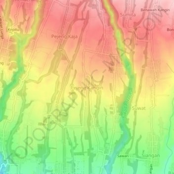
Name: Pejeng Kangin topographic map, elevation, terrain.
Location: Pejeng Kangin, Gianyar, Bali, 80552, Indonesia (-8.51004 115.27823 -8.47004 115.31823)
Average elevation: 276 m
Minimum elevation: 166 m
Maximum elevation: 357 m
Other topographic maps
Click on a map to view its topography, its elevation and its terrain.