
Thank you for supporting this site ❤️
Make a donation
Make a donation
Gear up for your next adventure:
As an Amazon Associate, this site earns from qualifying purchases at no extra cost to you.
Sipirra topographic map
Click on the map to display elevation.
Thank you for supporting this site ❤️
Make a donation
Make a donation
Gear up for your next adventure:
As an Amazon Associate, this site earns from qualifying purchases at no extra cost to you.
About this map
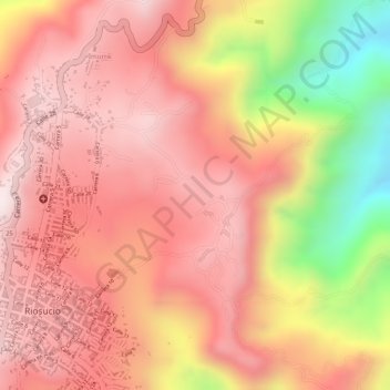
Name: Sipirra topographic map, elevation, terrain.
Location: Sipirra, Riosucio, Alto Occidente, Caldas, Colombia (5.41896 -75.70244 5.43896 -75.68244)
Average elevation: 1,670 m
Minimum elevation: 1,318 m
Maximum elevation: 1,828 m
Thank you for supporting this site ❤️
Make a donation
Make a donation
Gear up for your next adventure:
As an Amazon Associate, this site earns from qualifying purchases at no extra cost to you.