Geolocate

Sakthikulangara topographic map

Click on the map to display elevation.

About this map

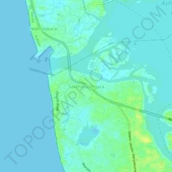
Name: Sakthikulangara topographic map, elevation, terrain.

Location: Sakthikulangara, Kollam, Kerala, 691581, India (8.90943 76.52875 8.94943 76.56875)

Average elevation: 4 m

Minimum elevation: -1 m

Maximum elevation: 16 m

Other topographic maps

Click on a map to view its topography, its elevation and its terrain.

Kundara

India > Kerala > Kollam

Average elevation: 31 m

Gear up for your next adventure:

👟Heavy Duty Boot Laces - Always carry a spare for your hiking footwear
📸Action Camera Chest Mounts - Record your ascent following topographic paths hands-free
🧴Tick Removal Tools - Small, essential health tool for UK woodland and moorland
📱Phone Mounts for Hiking - Secure mounts to carry your phone on trails
📱Rugged Phone Cases - Heavy-duty protection for smartphones used as secondary GPS tools

As an Amazon Associate, this site earns from qualifying purchases at no extra cost to you.