Geolocate

Arimbay topographic map

Click on the map to display elevation.

About this map

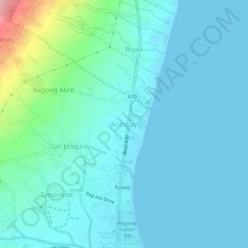
Name: Arimbay topographic map, elevation, terrain.

Location: Arimbay, Legazpi, Albay, Bicol Region, 4500, Philippines (13.16331 123.73252 13.20331 123.77252)

Average elevation: 20 m

Minimum elevation: -1 m

Maximum elevation: 137 m

Other topographic maps

Click on a map to view its topography, its elevation and its terrain.

Mayon Volcano

Philippines > Albay > Legazpi

Average elevation: 519 m

Sawangan Park

Philippines > Albay > Legazpi

Average elevation: 7 m

Kalayaan Park

Philippines > Albay > Legazpi

Average elevation: 7 m

Gear up for your next adventure:

🔋Solar Power Banks - Keep your GPS and phone charged during multi-day expeditions
🧭Professional Hiking Compasses - High-precision liquid-filled compasses for map reading and orientation
👟Men's Trail Running Shoes - Lightweight grip for fast movement over topographic contours
🧵Survival Paracord - Multi-purpose cordage for emergency repairs and shelters
💧Hydration Reservoirs - Convenient water bladders for hands-free drinking on the move

As an Amazon Associate, this site earns from qualifying purchases at no extra cost to you.