
Ardez topographic map
Interactive map
Click on the map to display elevation.
About this map
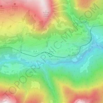
Name: Ardez topographic map, elevation, terrain.
Average elevation: 1,699 m
Minimum elevation: 1,241 m
Maximum elevation: 2,363 m
Other topographic maps
Click on a map to view its topography, its elevation and its terrain.
Zernez
Switzerland > Grisons > Region Engiadina Bassa/Val Müstair
Lai da Ova Spin is a compensation reservoir on the river Spöl. It is located in the upper areas of the Lower Engadine valley (Romansh: Engiadina Bassa). It is located at an elevation of 1,473 m (4,833 ft) and is connected to the railway network of the Rhätische Bahn. In Zernez, the stream Spöl empties into…
Average elevation: 2,297 m
Samnaun
Switzerland > Grisons > Region Engiadina Bassa/Val Müstair
Until 2017 it was part of the Ramosch sub-district, of the Inn district, after 2017 it was part of the Engiadina Bassa/Val Müstair Region. It is located in a left side valley of the Engadin valley, at an elevation of 1,700–1,840 meters (5,580–6,040 ft). It consists of five village sections; Compatsch,…
Average elevation: 2,369 m