
Rollegem topographic map
Interactive map
Click on the map to display elevation.
About this map
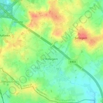
Name: Rollegem topographic map, elevation, terrain.
Location: Rollegem, Courtrai, Flandre-Occidentale, Flandre, Belgique (50.75058 3.24240 50.79360 3.28951)
Average elevation: 39 m
Minimum elevation: 17 m
Maximum elevation: 69 m
Other topographic maps
Click on a map to view its topography, its elevation and its terrain.
Kooigem
Belgique > Flandre-Occidentale > Courtrai > Courtrai
Kooigem, Courtrai, Flandre-Occidentale, Belgique
Average elevation: 26 m
Courtrai
Belgique > Flandre-Occidentale > Courtrai > Courtrai
Courtrai, Flandre-Occidentale, Flandre, 8500, Belgique
Average elevation: 24 m