
Dorve topographic map
Interactive map
Click on the map to display elevation.
About this map
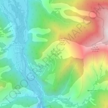
Name: Dorve topographic map, elevation, terrain.
Average elevation: 1,361 m
Minimum elevation: 911 m
Maximum elevation: 2,212 m
Other topographic maps
Click on a map to view its topography, its elevation and its terrain.
Espot
Spanje > Catalonië > Pallars Sobirà
Espot, Pallars Sobirà, Lerida, Catalonië, Spanje
Average elevation: 1,867 m
Vilamur
Spanje > Catalonië > Pallars Sobirà > Soriguera
Vilamur, Soriguera, Pallars Sobirà, Lerida, Catalonië, 25566, Spanje
Average elevation: 1,276 m