
Thadlaskein topographic map
Interactive map
Click on the map to display elevation.
About this map
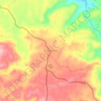
Name: Thadlaskein topographic map, elevation, terrain.
Location: Thadlaskein, West Jaintia Hills District, Meghalaya, India (25.48330 92.15310 25.52330 92.19310)
Average elevation: 1,349 m
Minimum elevation: 1,240 m
Maximum elevation: 1,414 m
Other topographic maps
Click on a map to view its topography, its elevation and its terrain.
Jowai
India > Meghalaya > Thadlaskein
Jowai (IPA: ʤəʊˈwaɪ) is the headquarters of the West Jaintia Hills district of the state of Meghalaya, India, and is home to the Pnar, a sub-tribe of the Khasi people. It is located on a plateau surrounded on three sides by the Myntdu river bordering Bangladesh to the south (about 50 km from the…
Average elevation: 1,332 m