Geolocate

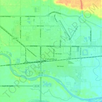
Columbus topographic map

Click on the map to display elevation.

Columbus

The city lies at an elevation of 1,447 feet (441 m). It is built on the flat terrain of the Platte River valley; rolling hills rise to the north of the city.

Wikipedia (CC-BY-SA 3.0)

About this map

Name: Columbus topographic map, elevation, terrain.

Location: Columbus, Platte County, Nebraska, United States (41.40238 -97.39830 41.46771 -97.29998)

Average elevation: 442 m

Minimum elevation: 431 m

Maximum elevation: 469 m

Other topographic maps

Click on a map to view its topography, its elevation and its terrain.
Oconee

United States > Nebraska > Platte County

Average elevation: 456 m

Gear up for your next adventure:

👕Technical Hiking Tees - Moisture-management for high-exertion climbs
🗺️Ordnance Survey Maps - Essential paper maps for hiking across the UK national parks
🔋Lithium AA Batteries - Long-lasting power that performs well in cold mountain weather
Altimeter Watches - Watches measuring altitude for mountain activities
👟Waterproof Leg Gaiters - Keep mud and water out of your boots in boggy terrain

As an Amazon Associate, this site earns from qualifying purchases at no extra cost to you.