Geolocate

Falset topographic map

Interactive map

Click on the map to display elevation.

About this map

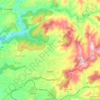
Name: Falset topographic map, elevation, terrain.

Location: Falset, Priorat, Tarragone, Catalogne, 43730, Espagne (41.13386 0.76068 41.18959 0.86337)

Average elevation: 361 m

Minimum elevation: 122 m

Maximum elevation: 668 m

Other topographic maps

Click on a map to view its topography, its elevation and its terrain.

Pradell de la Teixeta

Espagne > Catalogne > Priorat

Pradell de la Teixeta, Priorat, Tarragone, Catalogne, 43774, Espagne

Average elevation: 491 m

els Guiamets

Espagne > Catalogne > Priorat

els Guiamets, Priorat, Tarragone, Catalogne, 43777, Espagne

Average elevation: 205 m

la Torre de Fontaubella

Espagne > Catalogne > Priorat

la Torre de Fontaubella, Priorat, Tarragone, Catalogne, 43774, Espagne

Average elevation: 516 m