
Gaià topographic map
Interactive map
Click on the map to display elevation.
About this map
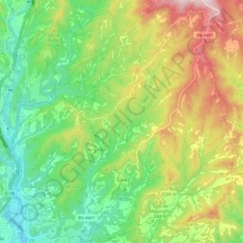
Name: Gaià topographic map, elevation, terrain.
Location: Gaià, Bages, Barcelone, Catalogne, Espagne (41.89850 1.88002 41.96726 1.97525)
Average elevation: 492 m
Minimum elevation: 316 m
Maximum elevation: 771 m
Other topographic maps
Click on a map to view its topography, its elevation and its terrain.
el Collet
Espagne > Catalogne > Bages > Sant Mateu de Bages
el Collet, Sant Mateu de Bages, Bages, Barcelone, Catalogne, 08269, Espagne
Average elevation: 701 m
Sant Joan de Vilatorrada
Sant Joan de Vilatorrada, Bages, Barcelone, Catalogne, 08250, Espagne
Average elevation: 295 m