
Make a donation
Gear up for your next adventure:
As an Amazon Associate, this site earns from qualifying purchases at no extra cost to you.
Poppel topographic map
Click on the map to display elevation.
Make a donation
Gear up for your next adventure:
As an Amazon Associate, this site earns from qualifying purchases at no extra cost to you.
Poppel
Poppel wordt gerekend tot de Noorderkempen. Het vlakke, zandige landschap varieert in hoogte tussen 21 en 31 meter. Vanaf 1850 hebben ontginningen plaatsgevonden en ontstonden er landgoederen zoals De Schrieken, en naaldbossen. De Molenheide, een bos in het uiterste noorden, an bij het Nederlandse natuurgebied Gorp en Roovert.
Make a donation
Gear up for your next adventure:
As an Amazon Associate, this site earns from qualifying purchases at no extra cost to you.
About this map
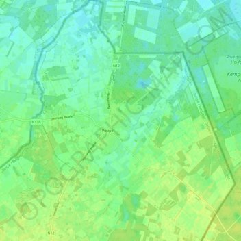
Name: Poppel topographic map, elevation, terrain.
Location: Poppel, Ravels, Turnhout, Antwerpen, 2382, België (51.41404 4.99806 51.48726 5.10457)
Average elevation: 24 m
Minimum elevation: 17 m
Maximum elevation: 32 m
Make a donation
Gear up for your next adventure:
As an Amazon Associate, this site earns from qualifying purchases at no extra cost to you.
Other topographic maps
Click on a map to view its topography, its elevation and its terrain.