
Make a donation
Gear up for your next adventure:
As an Amazon Associate, this site earns from qualifying purchases at no extra cost to you.
Hamilton Township topographic map
Click on the map to display elevation.
Make a donation
Gear up for your next adventure:
As an Amazon Associate, this site earns from qualifying purchases at no extra cost to you.
About this map
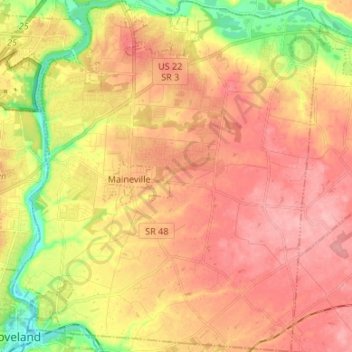
Name: Hamilton Township topographic map, elevation, terrain.
Location: Hamilton Township, Warren County, Ohio, 45039, United States (39.26452 -84.26526 39.36761 -84.14829)
Average elevation: 238 m
Minimum elevation: 173 m
Maximum elevation: 281 m
Make a donation
Gear up for your next adventure:
As an Amazon Associate, this site earns from qualifying purchases at no extra cost to you.
Other topographic maps
Click on a map to view its topography, its elevation and its terrain.
Make a donation
Gear up for your next adventure:
As an Amazon Associate, this site earns from qualifying purchases at no extra cost to you.
Corwin M. Nixon Pine Hill Lakes Park
United States > Ohio > Warren County > Mason
Average elevation: 250 m