
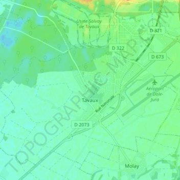
Tavaux topographic map
Interactive map
Click on the map to display elevation.
About this map
Name: Tavaux topographic map, elevation, terrain.
Average elevation: 194 m
Minimum elevation: 185 m
Maximum elevation: 213 m
Other topographic maps
Click on a map to view its topography, its elevation and its terrain.
Saint-Claude
Frankreich > Burgund und Freigrafschaft > Jura > Saint-Claude
Saint-Claude, Jura, Burgund und Freigrafschaft, Metropolitanes Frankreich, 39200, Frankreich
Average elevation: 814 m
Chancia
Frankreich > Burgund und Freigrafschaft > Jura > Chancia
Chancia, Saint-Claude, Jura, Burgund und Freigrafschaft, Metropolitanes Frankreich, 01590, Frankreich
Average elevation: 452 m
Moirans-en-Montagne
Frankreich > Burgund und Freigrafschaft > Jura > Moirans-en-Montagne
Moirans-en-Montagne, Saint-Claude, Jura, Burgund und Freigrafschaft, Metropolitanes Frankreich, 39260, Frankreich
Average elevation: 674 m
Thoirette
Frankreich > Burgund und Freigrafschaft > Jura > Thoirette-Coisia
Thoirette, Thoirette-Coisia, Lons-le-Saunier, Jura, Burgund und Freigrafschaft, Metropolitanes Frankreich, 39240, Frankreich
Average elevation: 428 m