
Make a donation
Gear up for your next adventure:
As an Amazon Associate, this site earns from qualifying purchases at no extra cost to you.
Labudovo Brdo topographic map
Click on the map to display elevation.
Make a donation
Gear up for your next adventure:
As an Amazon Associate, this site earns from qualifying purchases at no extra cost to you.
About this map
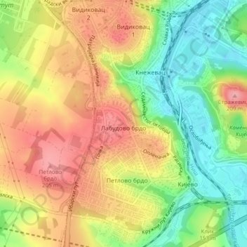
Name: Labudovo Brdo topographic map, elevation, terrain.
Average elevation: 150 m
Minimum elevation: 90 m
Maximum elevation: 207 m
Make a donation
Gear up for your next adventure:
As an Amazon Associate, this site earns from qualifying purchases at no extra cost to you.
Other topographic maps
Click on a map to view its topography, its elevation and its terrain.
Hotel Jugoslavija
Serbia > Central Serbia > City of Belgrade > Belgrade
The station was operational until 1970. To commemorate it, architect Milun Stambolić designed a memorial complex which consists of 5 pillars, which used to hold the station's overhang, and several meters of railroad tracks. The complex is placed on the plateau next to the hotel, on the small elevation above…
Average elevation: 77 m