Geolocate

Brea topographic map

Click on the map to display elevation.

About this map

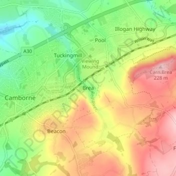
Name: Brea topographic map, elevation, terrain.

Location: Brea, Camborne, Cornwall, England, TR14 9BE, United Kingdom (50.19609 -5.29486 50.23609 -5.25486)

Average elevation: 127 m

Minimum elevation: 42 m

Maximum elevation: 223 m

Cornwall trails, hiking, mountain biking, running and outdoor activities

Other topographic maps

Click on a map to view its topography, its elevation and its terrain.

Praze Stream

United Kingdom > England > Cornwall > Camborne > Barripper

Average elevation: 79 m

Gear up for your next adventure:

🧊Insulated Flasks - Keeps drinks hot or cold during hikes
🎒Hiking Daypacks - Compact backpacks ideal for short hikes and excursions
📕Outdoor Navigation Books - Learn traditional and modern navigation techniques
👟Women's Trail Running Shoes - Agile footwear for fell running and technical trails
🔋Lithium AA Batteries - Long-lasting power that performs well in cold mountain weather

As an Amazon Associate, this site earns from qualifying purchases at no extra cost to you.