
Ganeshgule topographic map
Interactive map
Click on the map to display elevation.
About this map
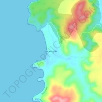
Name: Ganeshgule topographic map, elevation, terrain.
Location: Ganeshgule, Ratnagiri, Maharashtra, 415616, India (16.84316 73.27585 16.88316 73.31585)
Average elevation: 30 m
Minimum elevation: -1 m
Maximum elevation: 123 m
Other topographic maps
Click on a map to view its topography, its elevation and its terrain.
Golap
India > Maharashtra > Ratnagiri > Paawas
Golap, Paawas, Ratnagiri, Maharashtra, 415616, India
Average elevation: 61 m