
Castel Gandolfo topographic map
Interactive map
Click on the map to display elevation.
Castel Gandolfo
The maximum elevation registered in the territory is 425 metres (1,394 ft) above sea level, at the Collegio di Propaganda Fide adjoining Villa Barberini. On the crown of the hills around the Lake Albano, the elevation is only 400 metres (1,300 ft) above sea level, at the summit of Monte Cucco, bordering Marino.
About this map
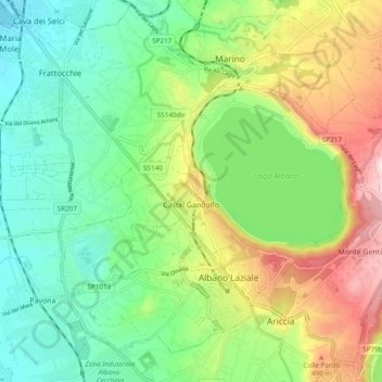
Name: Castel Gandolfo topographic map, elevation, terrain.
Location: Castel Gandolfo, Roma Capitale, 00073, Italy (41.72476 12.59258 41.76520 12.68832)
Average elevation: 306 m
Minimum elevation: 131 m
Maximum elevation: 633 m