
Make a donation
Gear up for your next adventure:
As an Amazon Associate, this site earns from qualifying purchases at no extra cost to you.
Rutshuru topographic map
Click on the map to display elevation.
Make a donation
Gear up for your next adventure:
As an Amazon Associate, this site earns from qualifying purchases at no extra cost to you.
About this map
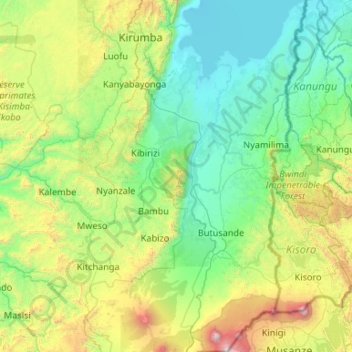
Name: Rutshuru topographic map, elevation, terrain.
Location: Rutshuru, North Kivu, Democratic Republic of the Congo (-1.50846 28.89439 -0.44945 29.68813)
Average elevation: 1,590 m
Minimum elevation: 908 m
Maximum elevation: 4,405 m
Make a donation
Gear up for your next adventure:
As an Amazon Associate, this site earns from qualifying purchases at no extra cost to you.
Other topographic maps
Click on a map to view its topography, its elevation and its terrain.
Make a donation
Gear up for your next adventure:
As an Amazon Associate, this site earns from qualifying purchases at no extra cost to you.
Make a donation
Gear up for your next adventure:
As an Amazon Associate, this site earns from qualifying purchases at no extra cost to you.
Make a donation
Gear up for your next adventure:
As an Amazon Associate, this site earns from qualifying purchases at no extra cost to you.
Lava Lake of Mount Nyiragongo
Democratic Republic of the Congo > North Kivu > Nyiragongo
Average elevation: 3,084 m