
Make a donation
Gear up for your next adventure:
As an Amazon Associate, this site earns from qualifying purchases at no extra cost to you.
Fox Covert topographic map
Click on the map to display elevation.
Make a donation
Gear up for your next adventure:
As an Amazon Associate, this site earns from qualifying purchases at no extra cost to you.
About this map
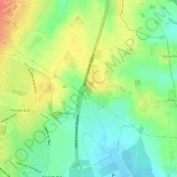
Name: Fox Covert topographic map, elevation, terrain.
Average elevation: 108 m
Minimum elevation: 85 m
Maximum elevation: 136 m
England trails, hiking, mountain biking, running and outdoor activities
Make a donation
Gear up for your next adventure:
As an Amazon Associate, this site earns from qualifying purchases at no extra cost to you.
Other topographic maps
Click on a map to view its topography, its elevation and its terrain.
Roughley
United Kingdom > England > Birmingham > Sutton Coldfield > Little Sutton
Average elevation: 139 m
Banners Gate
United Kingdom > England > Birmingham > Sutton Coldfield > New Oscott
Average elevation: 144 m
Make a donation
Gear up for your next adventure:
As an Amazon Associate, this site earns from qualifying purchases at no extra cost to you.
Walmley Ash
United Kingdom > England > Birmingham > Sutton Coldfield > Minworth
Average elevation: 99 m
Make a donation
Gear up for your next adventure:
As an Amazon Associate, this site earns from qualifying purchases at no extra cost to you.
Minworth Greaves
United Kingdom > England > Birmingham > Sutton Coldfield > Minworth
Average elevation: 90 m
Walmley Ash
United Kingdom > England > Birmingham > Sutton Coldfield > Minworth
Average elevation: 99 m