
Büchel topographic map
Interactive map
Click on the map to display elevation.
About this map
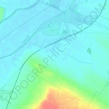
Name: Büchel topographic map, elevation, terrain.
Location: Büchel, Kindelbrück, Landkreis Sömmerda, Thuringia, Germany (51.22594 11.13503 51.25589 11.18683)
Average elevation: 139 m
Minimum elevation: 128 m
Maximum elevation: 184 m
Other topographic maps
Click on a map to view its topography, its elevation and its terrain.
Weißensee
Germany > Thuringia > Landkreis Sömmerda
Since October 2017, there has been a private weather station in Weißensee, whose data measured at an altitude of 143 m above sea level are permanently available on the Internet. A maximum temperature of 38.2 °C was measured there on 20 July 2022, and a minimum temperature of -24.4 °C on 10 February 2021.
Average elevation: 159 m