
Lemba topographic map
Interactive map
Click on the map to display elevation.
About this map
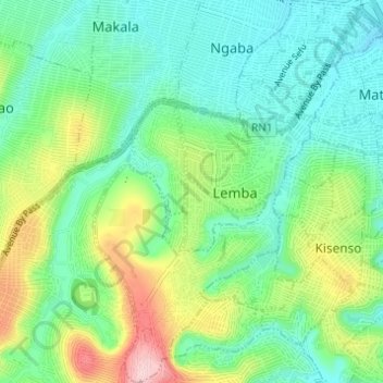
Name: Lemba topographic map, elevation, terrain.
Location: Lemba, Kinshasa, Democratic Republic of the Congo (-4.43436 15.30172 -4.37340 15.34881)
Average elevation: 351 m
Minimum elevation: 288 m
Maximum elevation: 500 m
Other topographic maps
Click on a map to view its topography, its elevation and its terrain.
Parc Naturel de la Nsele (Mangiers)
Democratic Republic of the Congo > Kinshasa
Average elevation: 276 m