
Make a donation
Gear up for your next adventure:
As an Amazon Associate, this site earns from qualifying purchases at no extra cost to you.
Kilsyth topographic map
Click on the map to display elevation.
Make a donation
Gear up for your next adventure:
As an Amazon Associate, this site earns from qualifying purchases at no extra cost to you.
Kilsyth
Historically part of Stirlingshire, Kilsyth is at an elevation of 200 feet (60 metres) above sea level and occupies a narrow strip of land between the Kilsyth Hills to the north and the River Kelvin to the south. To the east and west it is bordered by marshland and bogs. The centre of the town is close to the confluence of the Garrell and Ebroch burns.
Make a donation
Gear up for your next adventure:
As an Amazon Associate, this site earns from qualifying purchases at no extra cost to you.
About this map
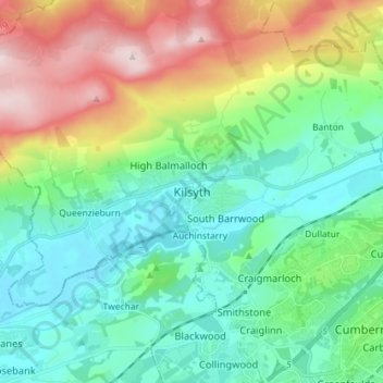
Name: Kilsyth topographic map, elevation, terrain.
Location: Kilsyth, North Lanarkshire, Scotland, G65 0AQ, United Kingdom (55.93654 -4.09597 56.01654 -4.01597)
Average elevation: 161 m
Minimum elevation: 34 m
Maximum elevation: 462 m
North Lanarkshire trails, hiking, mountain biking, running and outdoor activities
Make a donation
Gear up for your next adventure:
As an Amazon Associate, this site earns from qualifying purchases at no extra cost to you.
Other topographic maps
Click on a map to view its topography, its elevation and its terrain.
Cumbernauld
United Kingdom > Scotland > North Lanarkshire
Cumbernauld's name probably comes from the Gaelic comar nan allt, meaning "meeting of the burns or streams". There are differing views as to the etymology of this. One theory is that from its high point in the Central Belt, its streams flow both west to the River Clyde and east to the Firth of Forth so…
Average elevation: 113 m
Make a donation
Gear up for your next adventure:
As an Amazon Associate, this site earns from qualifying purchases at no extra cost to you.
Forrestburn Reservoir
United Kingdom > Scotland > North Lanarkshire > Bentfoot
Average elevation: 231 m
Cumbernauld
United Kingdom > Scotland > North Lanarkshire
Cumbernauld's name probably comes from the Gaelic comar nan allt, meaning "meeting of the burns or streams". There are differing views as to the etymology of this. One theory is that from its high point in the Central Belt, its streams flow both west to the River Clyde and east to the Firth of Forth so…
Average elevation: 113 m