
Make a donation
Gear up for your next adventure:
As an Amazon Associate, this site earns from qualifying purchases at no extra cost to you.
Achenkirch topographic map
Click on the map to display elevation.
Make a donation
Gear up for your next adventure:
As an Amazon Associate, this site earns from qualifying purchases at no extra cost to you.
Achenkirch
Die komplette Liste der Statistik Austria ist in: Topographische Siedlungskennzeichnung nach STAT
Make a donation
Gear up for your next adventure:
As an Amazon Associate, this site earns from qualifying purchases at no extra cost to you.
About this map
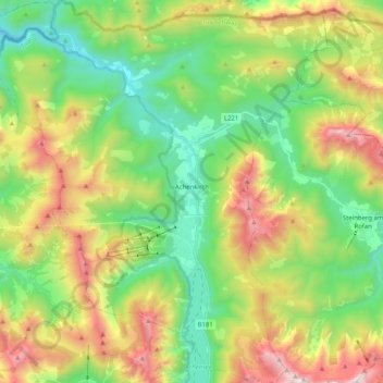
Name: Achenkirch topographic map, elevation, terrain.
Location: Achenkirch, Bezirk Schwaz, Tirol, 6215, Österreich (47.45730 11.60065 47.59456 11.77762)
Average elevation: 1,332 m
Minimum elevation: 790 m
Maximum elevation: 2,268 m
Make a donation
Gear up for your next adventure:
As an Amazon Associate, this site earns from qualifying purchases at no extra cost to you.
Other topographic maps
Click on a map to view its topography, its elevation and its terrain.
Zillertal
Österreich > Tirol > Bezirk Schwaz > Kaltenbach
Das Zillertal ist über die Zillertalstraße (B 169), die Anschluss an die Inntalautobahn bietet, erschlossen. Bei Zell am Ziller zweigt die Gerlosstraße (B 165) ab, die über den Gerlospass eine Verbindung ins Oberpinzgau darstellt. Die Zillertaler Höhenstraße ist eine kurvenreiche, mautpflichtige…
Average elevation: 1,499 m
Make a donation
Gear up for your next adventure:
As an Amazon Associate, this site earns from qualifying purchases at no extra cost to you.
Make a donation
Gear up for your next adventure:
As an Amazon Associate, this site earns from qualifying purchases at no extra cost to you.
Zillertal
Österreich > Tirol > Bezirk Schwaz > Kaltenbach
Das Zillertal zweigt etwa 40 km östlich von Innsbruck, nahe Jenbach, vom Inntal ab. Es hat seinen Namen von dem Fluss Ziller, der es von Süd nach Nord durchläuft und bei Strass im Zillertal in den Inn mündet. Im engeren Sinn reicht das Tal von Strass bis Mayrhofen. Es ist das breiteste der südlichen…
Average elevation: 1,503 m
Make a donation
Gear up for your next adventure:
As an Amazon Associate, this site earns from qualifying purchases at no extra cost to you.
Make a donation
Gear up for your next adventure:
As an Amazon Associate, this site earns from qualifying purchases at no extra cost to you.
Make a donation
Gear up for your next adventure:
As an Amazon Associate, this site earns from qualifying purchases at no extra cost to you.
Hinterriß
Österreich > Tirol > Bezirk Schwaz > Vomp
Hinterriß liegt auf 928 m ü. A. etwa in der Mitte des Rißtales. Dessen innerster Teil, die Eng, liegt im südöstlichen Viertel des Karwendelgebirges am westlichen Fuß der Sonnjochgruppe. Am nördlichen Rand des Gebirges hat das Tal bei Vorderriß Anschluss an den Isarwinkel, einen Abschnitt des Isartals.…
Average elevation: 1,246 m
Make a donation
Gear up for your next adventure:
As an Amazon Associate, this site earns from qualifying purchases at no extra cost to you.
Rastkogel
Österreich > Tirol > Bezirk Schwaz > Tux
Der Rastkogel liegt fünf Kilometer Luftlinie nordnordöstlich von Vorderlanersbach (Gemeinde Tux) im Tuxertal, dem westlichsten Seitental des Zillertals. Benachbarte Gipfel sind im Westen, durch das Nurpensjoch (2525 m) getrennt, die Halslpitze mit 2.574 Metern Höhe, und weiter gegen die Wattentaler Lizum…
Average elevation: 2,393 m
Zillertal
Österreich > Tirol > Bezirk Schwaz > Kaltenbach
Das Zillertal ist über die Zillertalstraße (B 169), die Anschluss an die Inntalautobahn bietet, erschlossen. Bei Zell am Ziller zweigt die Gerlosstraße (B 165) ab, die über den Gerlospass eine Verbindung ins Oberpinzgau darstellt. Die Zillertaler Höhenstraße ist eine kurvenreiche, mautpflichtige…
Average elevation: 1,499 m
Make a donation
Gear up for your next adventure:
As an Amazon Associate, this site earns from qualifying purchases at no extra cost to you.
Kleinschwendberg
Österreich > Tirol > Bezirk Schwaz > Gemeinde Schwendau > Schwendau > Kleinschwendberg
Average elevation: 1,041 m
Make a donation
Gear up for your next adventure:
As an Amazon Associate, this site earns from qualifying purchases at no extra cost to you.