
Samos topographic map
Click on the map to display elevation.
About this map
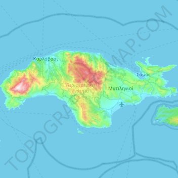
Name: Samos topographic map, elevation, terrain.
Location: Samos, Samos Regional Unit, Northern Aegean, Aegean, Greece (37.63610 26.56611 37.81311 27.06986)
Average elevation: 78 m
Minimum elevation: -1 m
Maximum elevation: 1,421 m
Other topographic maps
Click on a map to view its topography, its elevation and its terrain.
Kokkari
Greece > Northern Aegean > Samos Regional Unit > Municipal Unit of Vathy
Average elevation: 77 m
Agios Konstantinos
Greece > Northern Aegean > Samos Regional Unit > Municipal Unit of Vathy
Average elevation: 135 m
Kampos Marathokampou
Greece > Northern Aegean > Samos Regional Unit > Municipal Unit of Marathokabos
Average elevation: 99 m