
Musculdy topographic map
Interactive map
Click on the map to display elevation.
About this map
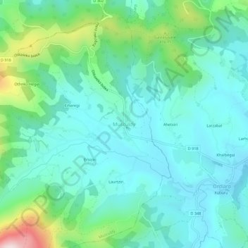
Name: Musculdy topographic map, elevation, terrain.
Average elevation: 281 m
Minimum elevation: 171 m
Maximum elevation: 679 m
Die Kapelle besitzt einen Glockengiebel in Form eines Clocher trinitaire. Er weist drei Spitzdächer als Symbol für die Dreifaltigkeit auf, das mittlere etwas höher als die beiden anderen. Wenn auf den Spitzdächern Kreuze angebracht sind wie im Fall dieser Kapelle, so spricht man auch von einem clocher calvaire, weil die Form an die Kreuzigung von Jesus Christus mit den beiden Dieben auf dem Berg Golgota erinnert.