
Fierbinți topographic map
Interactive map
Click on the map to display elevation.
About this map
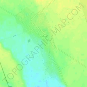
Name: Fierbinți topographic map, elevation, terrain.
Location: Fierbinți, Șelaru, Dâmbovița, 137426, Romania (44.49404 25.27499 44.51622 25.29633)
Average elevation: 154 m
Minimum elevation: 142 m
Maximum elevation: 163 m
Other topographic maps
Click on a map to view its topography, its elevation and its terrain.
Pucheni (Moroeni)
Pucheni (Moroeni), Moroeni, Dâmbovița, Romania
Average elevation: 695 m
Vadu Stanchii
Vadu Stanchii, Corbii Mari, Dâmbovița, 137144, Romania
Average elevation: 136 m