
Mahanoy City topographic map
Interactive map
Click on the map to display elevation.
Mahanoy City
Mahanoy City is located at 40°48′45″N 76°8′25″W / 40.81250°N 76.14028°W / 40.81250; -76.14028 (40.812413, -76.140223), with PA 54 as a main thoroughfare and through road, serving as a main street named Centre Street. To the west it connects to Shenandoah thence to the Susquehanna Valley and to the east reaches through several unincorporated villages then passes through Barnesville as Pine Creek Dr. and then serves Hometown as a main road, intersecting PA 309 (N-S) before passing into Tamaqua and Nesquehoning. The borough is situated in the valley of Mahanoy Creek, approximately 4 miles (6.4 km) southeast of Shenandoah and 11 miles (18 km) west-northwest of Tamaqua, both of which are reached via Route 54. Mahanoy City lies at an elevation of 1,240 feet (380 m) above sea level; Broad Mountain (1,795 feet (547 m)), a ridge extending through Schuylkill County, overlooks it on the southeast.
About this map
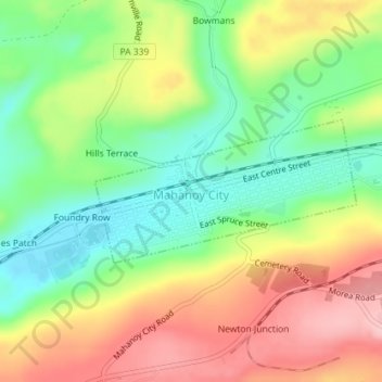
Name: Mahanoy City topographic map, elevation, terrain.
Average elevation: 435 m
Minimum elevation: 358 m
Maximum elevation: 527 m