Geolocate

Rochester topographic map

Click on the map to display elevation.

About this map

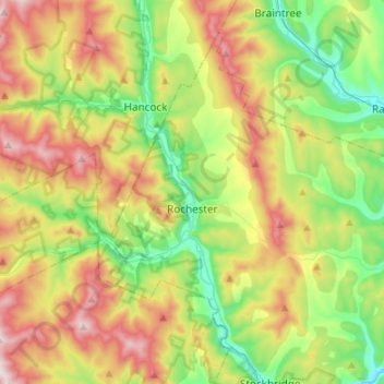
Name: Rochester topographic map, elevation, terrain.

Location: Rochester, Windsor County, Vermont, 05767, United States (43.80401 -72.98025 43.96224 -72.71228)

Average elevation: 516 m

Minimum elevation: 182 m

Maximum elevation: 1,041 m

Gear up for your next adventure:

🔦Outdoor Torches - Reliable torches for night navigation
🧗Locking Carabiners - Secure gear to your pack or for light technical use
👟Men's Trail Running Shoes - Lightweight grip for fast movement over topographic contours
🔦Waterproof LED Headlamps - Hands-free lighting for evening treks and emergency navigation
🧘Folding Sit Mats - Dry and warm seat for map-reading breaks on damp ground

As an Amazon Associate, this site earns from qualifying purchases at no extra cost to you.